In the dynamic world of subsurface engineering, the collaboration between geoscientists and reservoir engineers is a finely orchestrated dance. This blog uncovers how reservoir engineering analysis drives adaptations to geoscientific models, showcasing real-world examples of the interplay between engineering and geoscientific insights.
Engineering Insight Shaping Geoscientific Understanding
Reservoir engineering brings a unique perspective to the geoscientific landscape, influencing how we interpret and model subsurface formations. Here’s how engineering practices contribute to reservoir characterisation:
Dynamic Reservoir Modelling
Through sophisticated modelling techniques, reservoir engineers simulate fluid behaviour within the reservoir. These dynamic models provide valuable insights into how fluids flow and interact with geological structures. Using these insights, we can better understand the geology and properties of the formation, and thus construct a subsurface model that better represents the unseen reality beneath us.
Pressure and Flow Analysis
Reservoir engineering analysis yields critical data on pressure trends and fluid flow rates. Combined pressure and flow analysis is also called Pressure Transient Analysis (PTA), and is a pivotal technique in reservoir engineering. The purpose of PTA is to discern and interpret the behaviour of fluids within a reservoir over time. These studies provide information that is instrumental in refining geological models, especially in regions with complex subsurface dynamics.
Enhanced Well Performance
By optimising well design and completion strategies, reservoir engineers ensure that wells interact effectively with geological formations. This leads to higher production rates and improved reservoir management. While the immediate impact may not rewrite the historical understanding of geological features, well optimisation serves as a forward-looking initiative. It sets the stage for future data acquisition, providing an ongoing source of valuable information that progressively refines our geoscientific comprehension. In essence, well optimisation stands, not only as a technique for immediate production gains, but as a linchpin in the dynamic exchange of information between reservoirs, engineers, and geoscientists, shaping an evolving landscape of geoscientific understanding.
Case Studies: When Engineering Shapes Geology
Real world projects vividly illustrate the impact of reservoir engineering on geological understanding.
Case Study 1: Perched Water Contacts
Static well data, such as well logs, only provide data in the immediate vicinity of the well. This is a small window to try to understand reservoir structure. It isn’t until you turn to dynamic well data across a field, that the larger fluid dynamics can be understood.
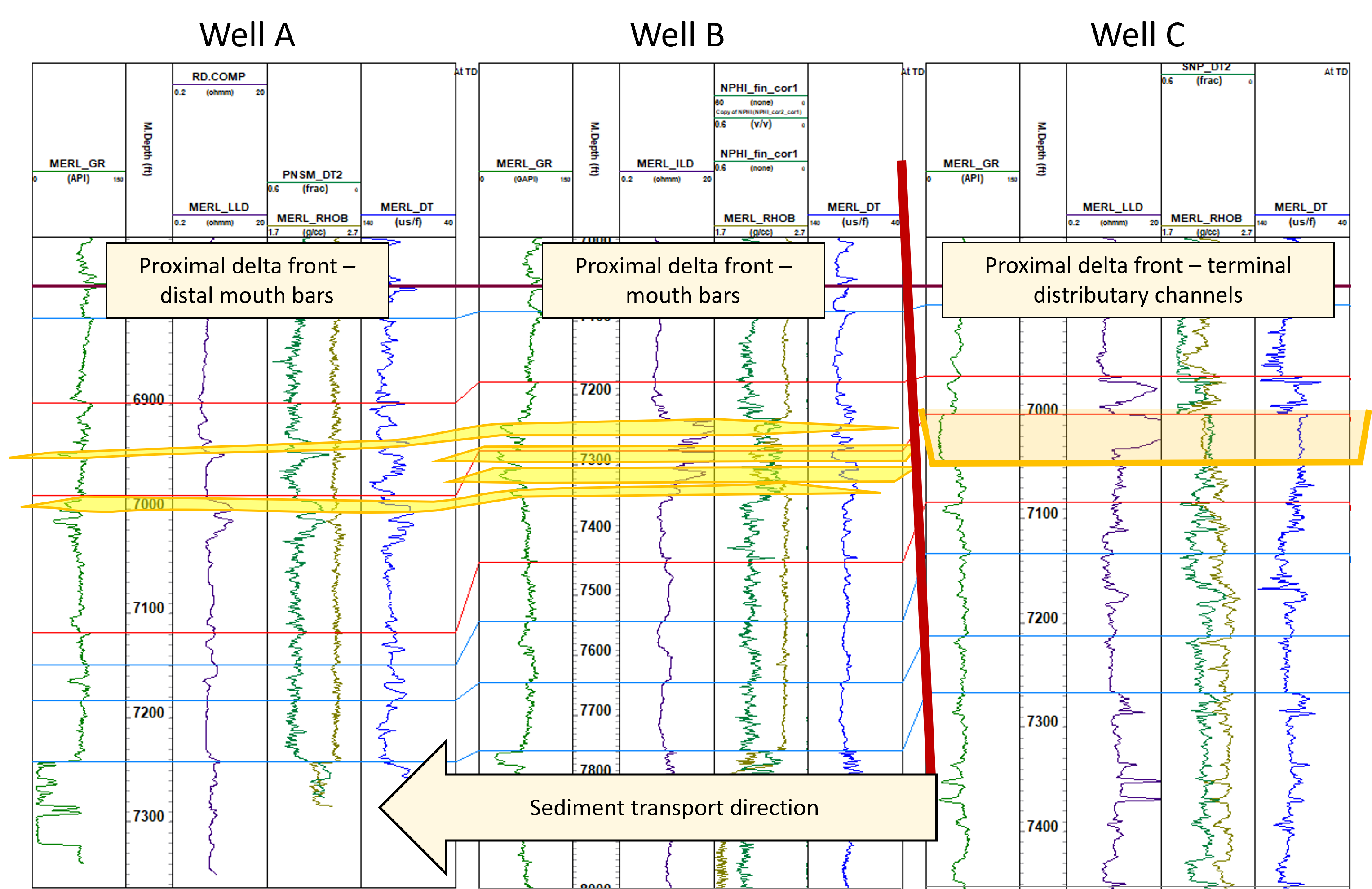
This situation was encountered in a recent field rejuvenation project carried out by Merlin, together with our partner Belltree. The field, positioned distally in the Niger Delta, has wells encountering distal delta sand lobes and, in one well, a channel sand deposit. Shale deposition provides both lateral and top seals for the reservoir sand units.

Saturation height interpretation of the stacked delta sands indicated each sand had a different contact depth. In the first instance, static volumetrics for each of the sand units were calculated on this basis (Initial Model below). However, the dynamic assessment of the wells indicated a larger volume was in communication with the well. A revised geological model was therefore required.
Considering the geoscientific elements of the setting, and likely additional dynamic pathways, a revised model was established. This model assumed that the channel crosscut the thinner delta lobe sands. On hydrocarbon charging, the main charge pathway was through the channel into the lobes. Due to the lateral shale seals, water was trapped in the distal parts of the lobes resulting in perched water.

Re-running the volumetrics with this new model provided a match between the static and dynamic interpretations. The data confirmed that the connectivity within the reservoir was maintained through to production, guiding future development plans.
Case Study 2: The importance of permeability
Having carried out reservoir modelling for the Rotliegendes of the Southern North Sea (SNS), a disconnect was identified between observed and modelled flow rates: the model was not producing enough gas. While the reservoir engineer could easily just apply a permeability multiplier, to make a robust case for the change, it is important to understand the geoscience behind the increase. The Rotliegendes of SNS is a prolific hydrocarbon reservoir and, with the move to CCS, remains an interval of interest for energy solutions. Much of the Rotliegendes is represented by good quality sandstones, with permeability in the range 10-100mD. However, in areas impacted by illitisation, this value significantly drops below this into the 0.1-10mD range.

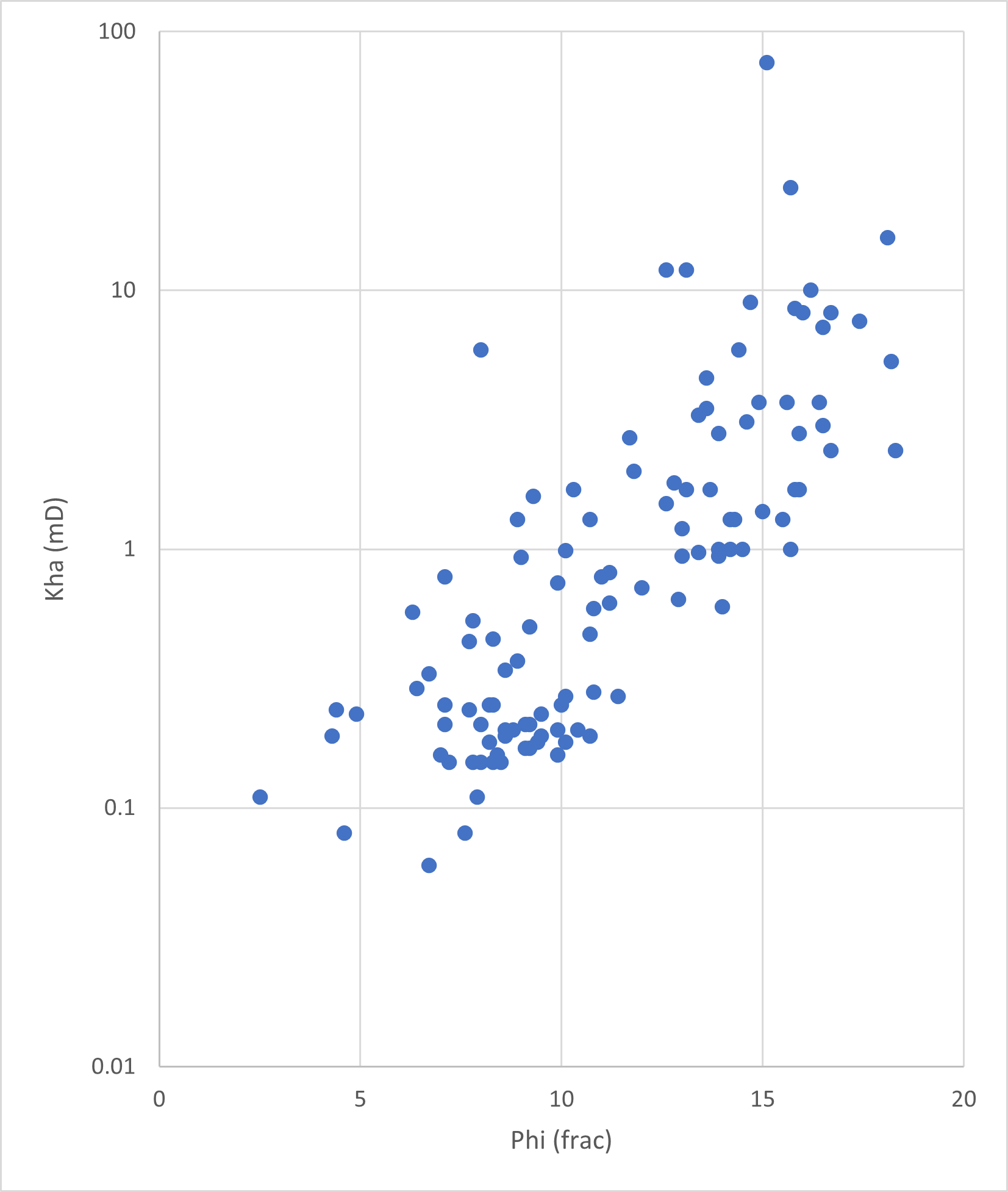
When distributing reservoir parameters into static models, the approach is often to look for trends between porosity and permeability data to determine a correlation between the two. The plot to the left shows an example of the porosity – permeability trend for the tight Rotliegendes of the SNS. You will note that there is a trend to the data below 10 mD, but above this, there are several points which no longer lie on the trend. On closer investigation not all of these can be attributed to fracture pathways, so what is causing the observed permeability increase?
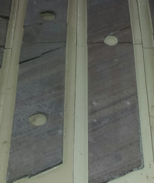
The Rotliegend is deposited in an aeolian setting and has a large proportion of dune facies. In this setting, wind erodes the windward side of the dune forcing grains up and over the crest of the dune, depositing them on the slipface. On closer inspection (see core photograph, right) these slipface deposits have variable grain sizes and permeabilities, with some very high permeability streaks identified. It is these streaks which are showing up in the core analysis, and which contribute to the increased permeability in the overall dune deposit. The core analysis only picks up these high permeability streaks if they are located at the position of the core plug.

The next challenge was to upscale the impact of the permeability streaks into an acceptable reservoir model scale. This was done by estimating the thickness and frequency of the streaks and applying a scaling factor to the original modelled permeability. This increase in permeability provided the uplift required to match the observed flow rates in the wells, and goes to show that knowing your rocks is the key to understanding how your model should work.
This intricate process emphasises the vital collaboration between reservoir engineers and geoscientists. Without a robust feedback loop between the two disciplines, this profound understanding of reservoir behaviour would have remained elusive.
Merlin’s Integrated Approach: Harnessing Synergy
At Merlin Energy Resources Limited, we understand the intricate dance between geoscience and engineering. Our team seamlessly integrates reservoir engineering analysis into geoscientific interpretations, ensuring a holistic understanding of subsurface dynamics.
Through this collaborative approach, we optimise reservoir characterisation, enabling our clients to make informed decisions for sustainable resource recovery.
Stay tuned for the final blog in this series, where we will explore strategies for maximising oilfield production through the combined efforts of geoscientists and reservoir engineers, showcasing real-world examples of successful production optimisation projects.
For more information about Merlin Energy Resources Limited and our expertise in subsurface engineering, please visit our website.


